
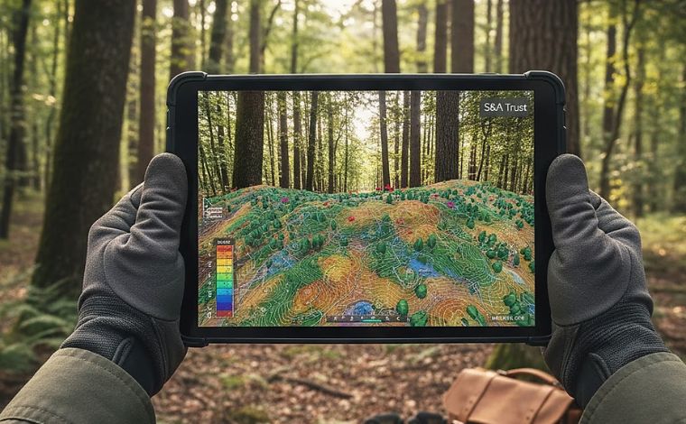
The days of managing land with a paper map and a compass are over. At S&A Trust, we utilize Geographic Information Systems (GIS) to “see” the property in layers. By stacking satellite data, soil audits, topographic contours, and utility proximities, we can make decisions with “Surgical Precision.” This is what we call Mapping the Unseen.
GIS allows us to identify “Micro-Climates” on the 24.25-acre tract. We can see exactly where the ridge-line wind is strongest, where the soil moisture is highest, and where the timber biomass is most concentrated. This data-driven approach removes the “Gambler’s Risk” from land ownership. We don’t hope the land is valuable; we prove it through multi-spectral analysis.
For our partners, this transparency is the ultimate “Trust Builder.” When we show a potential developer exactly where the fiber-optic proximity meets the 262-ft ridge, we are doing their work for them. We are providing a “Digital Twin” of the land that can be analyzed from a boardroom in Richmond or a home office in DC. In 2026, the best landowners are also the best data managers.
Interact with the Map. Access our Live Parcel Data Portal and GIS Layer Suite [Here].
What is a “Shapefile”? In the GIS world, a shapefile is the digital boundary of your land. It allows us to “drop” our property into any global database to check for everything from flight paths to secret mineral deposits.
Related Articles
- Topographic Authority
- The 92 Mean: Understanding Biomass Health
Author Bio
Authored by Jamiel Cotman, Principal Trustee of S&A Trust. With an extensive background in utility infrastructure and industrial logistics, Mr Cotman bridges the gap between raw land stewardship and the high-stakes world of mill operations. He manages S&A Trust with a focus on institutional-grade asset protection for the American landowner.